There's a lake in the far west of Nepal that most Nepalis have never stood beside — turquoise water sitting at 3,612 m (11,850 ft), boxed in by cliffs so dry and stark they could pass for the Tibetan plateau, because geologically, they basically are. Getting there took eight days: two overnight buses, four jeep transfers, three days of hard walking, and one short flight home. This is that trip — to Phoksundo Lake, deep inside Shey Phoksundo National Park.
Nepal's Only Trans-Himalayan Park
Shey Phoksundo isn't just any national park — it's Nepal's largest, and its only trans-Himalayan one. That second detail matters more than it sounds: sitting in the rain shadow of the main Himalayan range, the terrain here feels closer to the high, arid Tibetan plateau than to the green, terraced hills most people picture when they think "Nepal trek." Established in 1984, the park spans 3,555 km² (1,373 sq mi) across the remote districts of Dolpa and Mugu in Nepal's Mid-Western Region, with elevation climbing from 2,130 m to 6,885 m (6,988 to 22,589 ft). Its centerpiece, and the reason anyone makes this trip at all, is Phoksundo Lake itself — sitting at 3,612 m (11,850 ft), and one of the deepest, clearest bodies of water in the country.
Read more about the park on Wikipedia →
Who Made the Trip
I didn't do this one solo. Two trek partners signed on for the full eight days — and by day four, somewhere between our second jeep breakdown and our first real river crossing, I was very glad they had.
- Ashish Bikram Lamichhane
- Bipin Poon
The Route, Day by Day
Eight days, four jeep rides, roughly thirty hours of walking, and one flight — here's how it actually broke down.
Kathmandu → Rukum (Rari) — the trip starts before the trek does: a night bus grinding west out of Kathmandu, the kind of ride where you stop counting hours and just wait to see what the sunrise looks like somewhere unfamiliar.
Rari → Tallu → Khadang → Tripurakot → Dunai (4 jeep transfers) — one of the longest jeep days of the whole trip, broken into four separate legs and ending in Dunai, the last real town before the trail begins.
Dunai → Kageni → Chepka → Rechi (10 hours on foot) — this is where the trek proper starts, and it doesn't ease you in. Ten hours following the Suli Gad gorge as the trail narrows and the villages thin out to almost nothing.
Rechi → Ringmo → Phoksundo (5 hours on foot) — a shorter day through Ringmo village, and then, finally, Phoksundo. Every bus, every jeep, that ten-hour slog the day before — it's all just the entry fee for this view.
Phoksundo → View Point → Rechi (8 hours on foot) — one day at the lake before turning back: up to a viewpoint high above the water, then back down to Rechi, eight hours round trip and worth every minute of it.
Rechi → Suligad (6 hours on foot), then → Jhupal Airport (1 hour by jeep) — the last walking day, followed by the first sign in a week that civilization, and a flight home, actually existed.
Jhupal Airport → Nepalgunj → Kathmandu (flight) — two legs, one flight, and eight days of dust, jeep rides, and lake water behind us.
Days 1–2: The Night Bus West
Most treks in Nepal start with a bus. This one starts with a bus that doesn't stop. We left Kathmandu on a night bus heading west, out of the valley, down to the plains and across almost half the country, toward Rukum and the village of Rari, where the jeep roads into Dolpa begin.
Night buses in Nepal have a rhythm of their own. The lights go off, the music doesn't, and you drift in and out of sleep while the bus climbs, drops, brakes and swings round bends you can feel but can't see. Every so often it stops at a roadside dhaba for tea and dal bhat at an hour that makes no sense, and everyone piles out, stretches, and piles back in. By the time the sun came up we were somewhere none of us had been before, with hills that already looked different from the ones at home: drier, browner, bigger.
Dolpa is one of the most remote districts in Nepal, and those first two days are the reason. There is no quick way in. You earn it one long ride at a time.
This is an eight-day trek. The first three days involve zero trekking.
Day 3: Four Jeeps to Dunai
Day 3 was the jeep day, and it wasn't one jeep. It was four. From Rari to Tallu, Tallu to Khadang, Khadang to Tripurakot, and Tripurakot to Dunai, each leg a different vehicle on a different stretch of dirt road, with bags hauled off one roof and onto the next in between.
These are proper mountain roads: one lane wide, carved into the side of the valley, with the river a long way below and no barrier between you and it. The jeeps bounce, lurch and occasionally slide, and you learn quickly to hold on to whatever is closest and not look down too often. It's tiring in a way that's hard to explain, because you've been sitting all day and somehow every muscle hurts.
The day ends in Dunai (2,140 m / 7,021 ft), the headquarters of Dolpa District and the last real town before the trail. Shops, a few hotels, a bridge over the Thuli Bheri river, and the last chance to buy anything you forgot.
Four jeeps in one day. By the evening we could rate suspension systems like wine critics: “this one has notes of broken spring, with a long, bumpy finish.”
Day 4: Up the Suli Gad to Rechi
Day 4 was the first day of actual walking, and it was 10 hours long. From Dunai the trail follows the Suli Gad, the river that flows down from Phoksundo Lake, upstream through Kageni and Chepka to Rechi.
Near Suligad you pass the entrance to Shey Phoksundo National Park, and from there the gorge narrows. The trail runs along the river most of the day, sometimes right beside the water, sometimes high above it on a path cut into the cliff, crossing back and forth on wooden and suspension bridges. The villages get smaller and further apart, and the landscape starts to change: fewer terraces, more bare rock, and pine forest clinging to the slopes. You can feel the dry trans-Himalaya getting closer with every hour.
We reached Rechi (2,940 m / 9,646 ft) tired, dusty and very ready for dinner. Ten hours on the first trekking day, after three days of buses and jeeps, is a big ask of the legs.
The first day of walking is also the longest one. Whoever planned this route clearly believes in getting the hard part over with.
Day 5: Ringmo and Phoksundo Lake
Day 5 was only 5 hours, and it was the day everything paid off. From Rechi the trail climbs steadily up the valley, and partway up you get your first big surprise: Phoksundo Falls, a long white ribbon of water pouring off the cliffs, often called the highest waterfall in Nepal. That water comes straight out of the lake, which means the lake is somewhere above it, just out of sight.
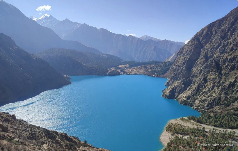
A final climb takes you over a ridge, and then there it is. Phoksundo Lake (3,612 m / 11,850 ft) is a colour that doesn't look real: a deep, glowing turquoise, framed by bare grey and brown cliffs and snow peaks behind. It's the deepest lake in Nepal, and the water is so clear and still on a calm day that the cliffs reflect perfectly in it.
Right by the lake sits Ringmo (3,640 m / 11,942 ft), a small village of flat-roofed stone houses, prayer flags and stacked firewood that looks more like Tibet than anywhere most people think of as Nepal. Many of the people here follow Bon, the old religion of the region, which is older than Buddhism in Tibet, and there's a small monastery on the lake shore. We spent the night beside the lake, and it was very hard to stop looking at it.
The shortest walking day of the trek had the biggest reward. Turns out you have to walk ten hours to earn five.
Day 6: The View Point, Then Back to Rechi
We had one day at the lake, and we used it. Day 6 started with the climb to a view point high above the water, at around 3,900 m (12,795 ft), the highest point of our trip. From up there you see the whole lake at once: the long turquoise curve of it, the village and monastery on the shore, and the cliffs dropping straight into the water on the far side.
Along the western side of the lake, a narrow trail is cut into those cliffs, high above the water, heading north toward the inner Dolpo and Shey Gompa beyond. Standing at the view point and looking at it, you start to understand just how far into the mountains this place really is.
Then it was time to turn round. We came back down past Ringmo and the waterfall and all the way to Rechi for the night: about 8 hours in all, and the last time we would see that colour of water for a long time.
You may have seen this lake before without knowing it. The Oscar-nominated 1999 film Himalaya (also called Caravan) was shot in Dolpo, and its yak caravan on that terrifying cliff path above the turquoise water is one of its most famous scenes.
Day 7: Suligad and Jhupal
The last walking day was 6 hours from Rechi back down the Suli Gad to Suligad, retracing the gorge we had climbed three days earlier. Going down is quicker, and it's a chance to see the valley again from the other direction, now that you know what's waiting at the top.
At Suligad a jeep took us about an hour up to Jhupal (2,475 m / 8,120 ft), home to Dolpa's airport. After a week of trails, jeeps and dust, seeing a runway felt almost unreal, like proof that the rest of the world was still out there.
It took three days of buses and jeeps to get into Dolpa. Getting out only needs one runway, if the weather agrees.
Day 8: Flying Home
The last day was the flight out: a small plane from Jhupal down to Nepalgunj on the plains, and then on to Kathmandu. From the window you can see the mountains you spent a week inside fall away behind you, ridge after ridge, until it's all flat, green and hot.
Eight days, two night buses, four jeeps, three hard days of walking and one turquoise lake. Hard, remote and absolutely worth it.
Three days to get there by road. A few hours to get home by air. The lake, however, stays with you a lot longer than either.
Budget & Difficulty
Plan your own Shey Phoksundo trek
General facts for anyone planning this trip, not just mine. Permit fees change often, so check with the Nepal Tourism Board before you go.
| Days | About 8–12, including flights to Juphal via Nepalgunj |
|---|---|
| Highest point | Phoksundo Lake about 3,612 m / 11,850 ft |
| Difficulty | Moderate; remote, with long days and basic lodges |
| Best time | Late May–October (Dolpo is in a rain shadow, so even the monsoon is fairly dry) |
| Permits (foreigners) | Shey Phoksundo National Park permit, plus a Lower Dolpo restricted-area permit (arranged through a registered trekking agency) |
| Guide | Required for restricted areas |
Questions people ask
Where is Shey Phoksundo Lake?
In Dolpa district in western Nepal, inside Shey Phoksundo National Park. It is Nepal’s deepest lake, famous for its deep turquoise colour.
How do you get to Phoksundo?
Most people fly Kathmandu to Nepalgunj, then a small plane to Juphal, and walk about 3 days via Dunai and Chhepka to Ringmo village on the lake shore.
What permits do I need?
A national park entry permit and, for foreigners, a Lower Dolpo restricted-area permit arranged through a registered trekking agency with a licensed guide.
When is the best time to visit?
Late spring to autumn. Because Dolpo sits behind the Himalaya, it gets far less monsoon rain than most of Nepal.
The budget starts at NPR 25,000 per person, and that's a minimum. Most of the money doesn't go on the trek itself. It goes on getting there and back: the night bus west, the four jeep legs to Dunai, the jeep up to Jhupal and the flight out via Nepalgunj. Food and beds along the trail are simple and fairly cheap, but prices climb the further you get from the road, because everything up here arrives on a mule or on someone's back. Bring extra for a weather delay at Jhupal.
We rated it hard, and not because of the altitude. The highest point, the view point above the lake, is only around 3,900 m (12,795 ft), lower than most of the big Nepal treks. What makes Shey Phoksundo hard is everything around the walking: three days of rough travel before you take a step, a 10-hour first day up the gorge, and a remote valley where help, shops and signal are a long way off. It's a trek for people who are comfortable being properly far from everything.
If You're Going
- Leave room in the plan. Jeep roads in Dolpa wash out and flights from Jhupal depend on the weather, so a spare day or two at the end takes a lot of stress out of the trip.
- Check your permits before you go. You'll pay a national park entry fee, and foreign trekkers need extra permits for Dolpa, so sort them out in Kathmandu, not on the trail.
- Carry enough cash. Don't count on finding an ATM or card payments once you leave the bigger towns. Dunai is your last real chance to stock up on anything.
- Pack for dust and sun. A buff or mask for the jeep rides, sunglasses and sunscreen for the dry, bright trail, and warm layers for the nights by the lake, which get cold even in season.
- Treat your water. Bring purification tablets or a filter so you can refill from the streams instead of buying bottles all the way.
- Respect the lake. Phoksundo is sacred to the people of Ringmo. Walk clockwise around chortens and mani walls, ask before photographing people, and don't swim or wash in the lake.

Planning this route? Feel free to reach out with anything the post doesn't answer: the buses and jeeps, the trail, permits, budget. I'm happy to help.
Email me about Shey Phoksundo →Watch the Trip
Photos From the Trail
More photos from this trip are coming soon.
Some treks you do for the view. Shey Phoksundo, you do for everything it takes to get there.